E911 Link gives dispatchers information to RIMS CAD instantly. With E911 Link RIMS automatically displays the CAD Incident screen as soon as the phone is answered.
RIMS identifies the caller’s location (“ALI”), verifies the location in the RIMS Street database, and is able to include in the display the original location and telephone number plus reference information associated with the location.
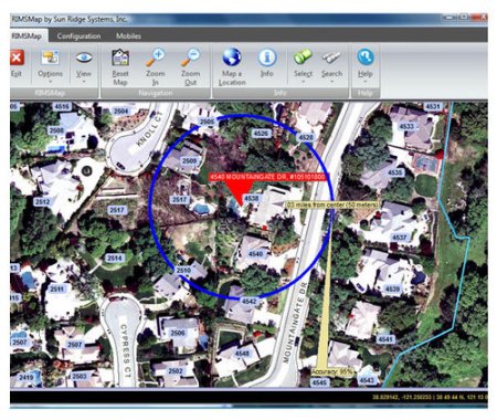
RIMS E911 Link displays the location of wireless callers and measures confidence.
Based on the available data from the agency’s 911 provider, the following information can be populated as part of the CAD Incident and/or RIMS Map:
Caller’s Name
Beat
Area
Map page
Responsible police, fire, and EMS agencies
Fire run card
Place (name) associated with location
Premise indicator
Hazard indicator
Previous incidents at this location
Latitude / Longitude / Uncertainty and Confidence
Class of service
From that point, dispatching can be as simple as easily completing in the Incident type and clicking on “Recommended Units” to dispatch the incident.
RIMS MAP INTEGRATION
RIMS E911 Link software is Wireless Phase II compliant. Wireless call information is seamlessly transferred into the CAD Incident screen. When using RIMS Map, both wired and wireless calls are immediately displayed on the dispatcher’s map. For wireless calls, a circle is automatically drawn around the caller based on the certainty and confidence factors that are part of the telephone company’s information delivered to RIMS.
NEXTGEN 911
Text messages and video/audio files can be quickly connected to RIMS CAD Incidents as attachments.

